
Planys conducted underwater inspection for a newly constructed berth in South India. Prior to release of payment, a post-construction due diligence was to be conducted to provide visual evidence of the work completion to the port consultant.
Scope of Work: Visual inspection of two berths of 700m each having piles of maximum depth of 17m. The inspection aimed to identify locations of exposed geo-textile layer, exposure of re-bars on earth retaining structure (ERS), absence of boulders on the slope protection works/rock bund and presence of any other construction defects.
Planys Solution: The inspection was carried out by Planys’ ROV Beluga equipped with high resolution camera, turbid water module, altimeter and depth sensor.
- Over 120+ construction defects were found, locations of rebars exposed, geo-textile layer exposed and at several sections on the slope, boulders were found missing.
- Defects were categorised by severity (major/moderate/minor) and also by type (cavity/rebar exposed, stone missing) marked on construction drawing.
- All anomalies/defects were plotted against geo-tagged CAD drawing of every section on the Planys Analytics Dashboard (PAD) with localised click-to-view video feature. The report was given to the consultant for further suggestions and relevant action point for re-work.
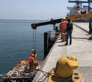

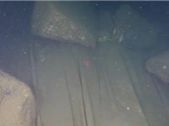
Images show deployment & setup of the ROV system and defects captured during inspection
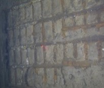
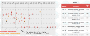
Images show defects captured during inspection with Planys ROV & snapshot of the “defects hot-spot” map delivered to client for a certain section on Planys Analytics Dashboard (PAD)